Horizontal - Full Color

How to find the best attractions to visit during a trip

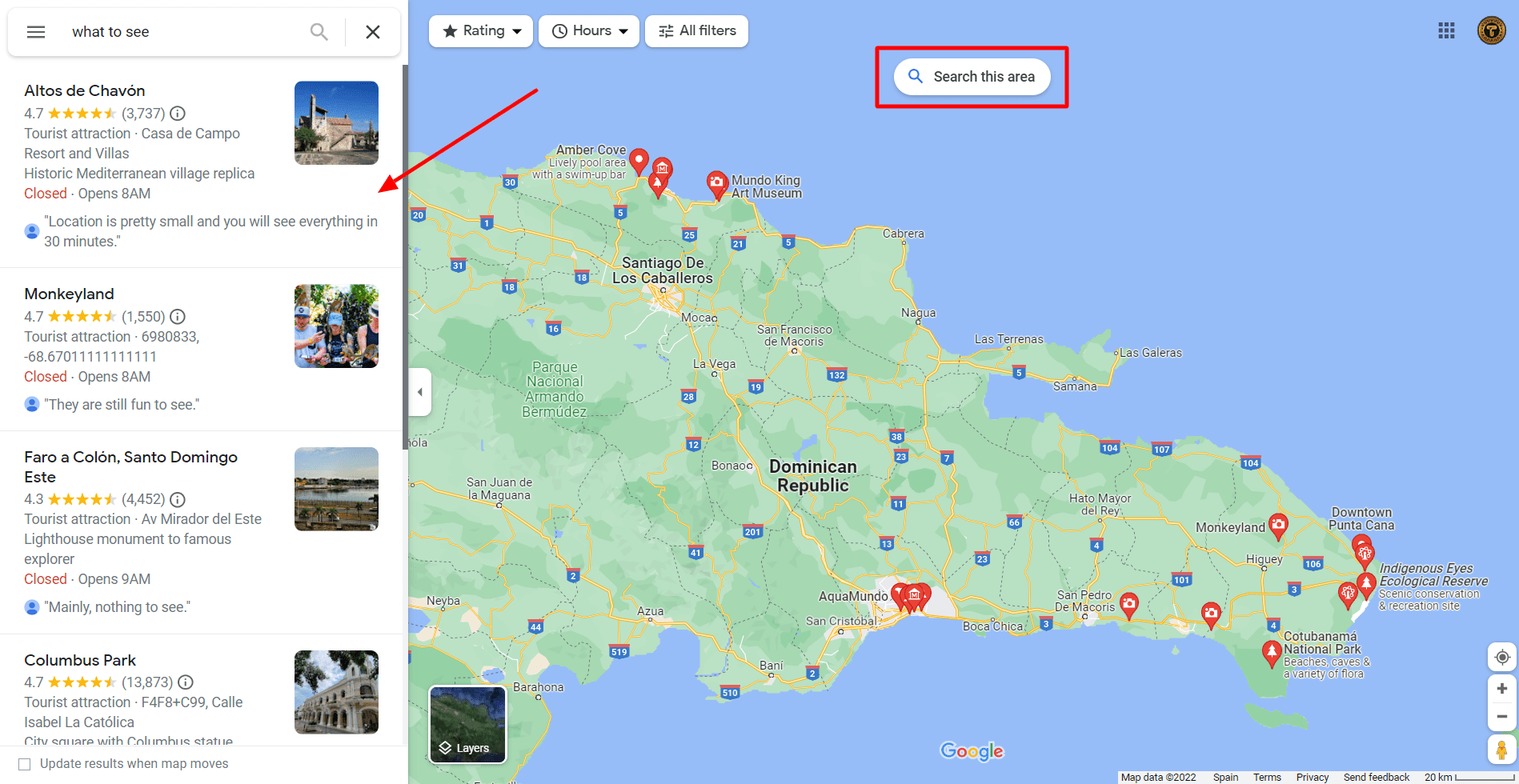
Whenplanning a trip, where should you go look for the must-sees? You can look at blog posts, TripAdvisor, or recommendations from other travelers, but those make it hard to plan a trip. In this article, we’ll show you a way to have all the essential landmarks to visit at a destination. Which also makes it really easy to plan a route and get directions once you start your trip.

There are many ways to plan a trip, some people have their own way and others are not really sure where to start. Blog posts are very efficient to get to know the information about the landmarks proposed by the writer. Sometimes those are just the places the author of the blog had time to visit during his trip. Or maybe those are personal preferences. That’s why today, we’ll show you how to plan a trip using our favorite travel tool here at Tralei: Google Maps.

Introduction

In order to use this feature you should have a Google account, but who doesn’t have one right? In this way, you will be able to sync everything between devices. For this demonstration, we will be using google maps on a laptop, but it is the same if you use your phone.

For this example, we will be planning a trip around the Dominican Republic.

Step 1. Searching.

To start searching for the must-sees on our destination we have to type “What to see in {destination}”  on the search bar and replace {destination} with the place you are visiting. In case you are already at your destination or the area you selected is too big (Like in the case of the Dominican Republic) just type “What to see” and move around the map until you get the full sight of the area you plan on visiting. Then Click on “Search This Area”  (See image below for references)

After doing this you’ll see a list of options. The good thing about searching for places this way is that Google lists the top attractions from people, so you are not getting the opinion from a single user. You also have reviews about the place and pictures that have been taken all year round. So you can see how it will look like during the season you are planning to visit. Normally pictures are unedited so you will get a real feel of how the attraction will look. Also, the hours of operation will be more accurate as businesses and attractions themselves normally update them. 

Step 2. Saving.

After taking a look at what attractions you would like to visit you should start saving them. To do so, click on the place you would like to visit and then on the bookmark or save icon.

After that, you will be prompted with multiple options. 

The best way to use them is to assign a meaning to each one, for example, “Favorites” means must-sees and will describe the main route. “Want to go” are places that are worth visiting if you have enough time but can be discarded. “Travel Plans” could be for rainy days or for places you want to sleep or restaurants… and so on. You can alternatively create your own list but note that all locations will display the same icon.

Note that every Travel article from Tralei contains a link to a custom travel list on Google Maps.

Continue saving all the attractions that you think may be worth visiting using this method.

Step 3. Creating the route.

Once you are done adding all the attractions it will look like something like the image on the right. Now, knowing where you are flying/starting the trip you can see distances between points to see how many you can see in one day.

Make sure you add multiple destinations to the same route so you can see how long it will take for the total day and to rearrange the stops to see what order is faster.

You can also see biking, walking and public transport routes and distances when available.

Note that this example is to plan a car trip but it is the same if you want to visit a city. You would just type the city name and repeat the process.

Step 3. Creating the route.

Once you are done adding all the attractions it will look like something like the image below. Now, knowing where you are flying/starting the trip you can see distances between points to see how many you can see in one day.

Make sure you add multiple destinations to the same route so you can see how long it will take for the total day and to rearrange the stops to see what order is faster.

You can also see biking, walking and public transport routes and distances when available.

Note that this example is to plan a car trip but it is the same if you want to visit a city. You would just type the city name and repeate the process.

Extra tip.

Once you are done we recommend you downloading an Offline Map of the area you are going to visit so you can navigate when there is no service. We have an article explaining how it works here.

If you think we forgot to mention anything, or have any other Google maps tips you want to share don’t hesitate to write in the comment section!

Thank you for reading!

Leave a Reply

Your email address will not be published. Required fields are marked *

Translate Page

Enter your email to get the checklists.

We will send them straight to your email so you can always access them.

*Make sure to check your promotions tab if using Gmail.

travel checklist download. Tralei

Rellene el formulario y le llamaremos